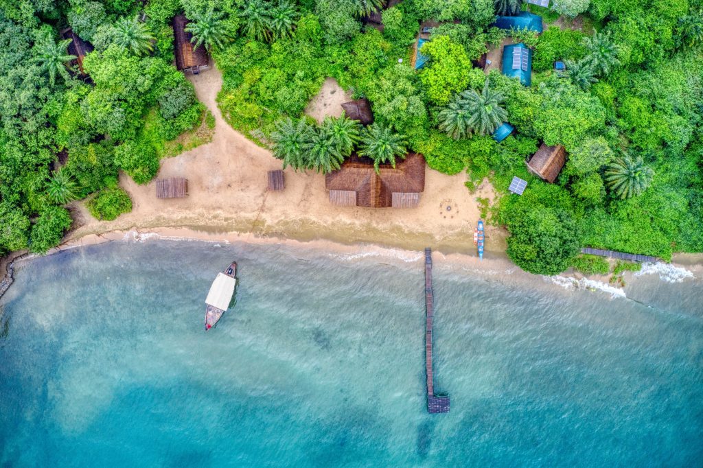
Where Is Mahale Located?
Mahale Mountains National Park is in far western Tanzania, on the eastern shore of Lake Tanganyika in the Uvinza District of the Kigoma Region, roughly 130 kilometres south of Kigoma town. Visitors reach it by light aircraft or boat on a Mahale chimpanzee trekking safari, since the park has no internal roads. Mahale covers around 1,600 square kilometres of forested mountains rising from the lakeshore, and was gazetted as a national park in 1985.
Coordinates put it near 6 degrees 16 minutes south and 29 degrees 56 minutes east. That places you closer to the Democratic Republic of Congo, visible across the water on clear days, than to any Tanzanian city of size.
Where Mahale Sits in Western Tanzania
Tanzania’s tourism is usually described in circuits, and Mahale belongs to the western one, the least visited of them. The northern circuit around Arusha holds the Serengeti, Ngorongoro and Kilimanjaro. The southern circuit runs to Ruaha and Nyerere. The west is Katavi, Gombe Stream, Mahale and Lake Tanganyika, and it sees a tiny share of the country’s visitors.
Distance is the reason. Mahale is around 1,500 kilometres from Arusha as a driver would travel it, across country where the roads deteriorate badly in the rains, and the last stretch cannot be driven at all. Getting from northern Tanzania to Mahale by road takes two or three days to reach Kigoma and then a boat.
What that isolation has bought is a park with roughly 700 to 1,000 eastern chimpanzees, described by park authorities as the largest protected population of the subspecies, and annual visitor numbers in the low thousands.
Orient yourself this way: put Lake Tanganyika on your left and the Tanzanian interior on your right. Mahale is the block of mountains between them, running northwest to southeast, with every camp on the lake side and nothing at all on the eastern boundary.
Mahale on the Shore of Lake Tanganyika
The park’s western boundary is the lake itself, which is the defining fact of its location. Lake Tanganyika runs roughly 673 kilometres north to south, reaches about 50 kilometres wide and drops to 1,470 metres, making it the world’s longest freshwater lake and the second deepest after Baikal.
Four countries share it: Tanzania, the Democratic Republic of Congo, Burundi and Zambia. From the Mahale beaches you are looking west across roughly forty to fifty kilometres of open water at the Congolese shore, which shows as a low line of highlands on clear evenings.
The lake surface sits at about 770 metres, and the Mahale range climbs from that to Mount Nkungwe at around 2,462 metres. Almost the entire vertical extent of the mountains is visible from a boat, which is why the arrival is what people remember.
How Far Mahale Is From Kigoma
Kigoma is the nearest town of consequence and the gateway to the park, sitting at the northeastern corner of the lake. Mahale lies south of it along the shoreline.
By light aircraft the flight takes about forty five minutes. By speedboat the same distance takes four to six hours. Wooden timber boats run it in fifteen hours or more, and the lake steamer takes around ten hours to reach the Mahale stop at Lagosa, also called Mgambo, where a park boat comes out to collect passengers.
Road access reaches only as far as the park boundary area. A track improved by the park authority now allows a four wheel drive vehicle to get from Kigoma to park headquarters in five or six hours during the dry season, depending on the wait at the Lugulu ferry. Older routes ran south via Simbo village across the Malagarasi river, or 122 kilometres to Sigunga village for a boat pickup arranged with park headquarters.
Mahale in the Kigoma Region and Uvinza District
Administratively, the park falls in Uvinza District within Kigoma Region, one of Tanzania’s more remote administrative areas. Kigoma town is the regional capital and economic centre, sitting next to the historic settlement of Ujiji, where Livingstone’s travels put the place in nineteenth century history books.
Around the park lives a scattered rural population, and the wider area is known as the Greater Mahale Ecosystem, covering close to 20,000 square kilometres and forming part of the Eastern Afromontane biodiversity hotspot. The Tongwe people are the community historically associated with these mountains, and Mount Nkungwe holds sacred significance in their tradition.
Conservation work in the region reflects that human context. The Tuungane project, run by The Nature Conservancy with Pathfinder International and partners including Frankfurt Zoological Society, the Jane Goodall Institute, the Tongwe Trust and Tanzania National Parks, works across the ecosystem on fisheries, forest protection, health services and village land use planning.
Mahale’s Neighbours on the Western Safari Circuit
Two other parks sit within reach and are commonly combined with Mahale on a single trip.
Gombe Stream National Park, to the north
A narrow strip of forest on the lakeshore north of Kigoma, reached by boat from town. At around 35 square kilometres it is tiny next to Mahale, holds roughly 95 chimpanzees, and carries the higher park entry fee of the two. This is where Jane Goodall’s work began.
Katavi National Park, to the southeast
A large, dry, seldom visited savanna park with buffalo, hippo and elephant, inland from the lake. Scheduled flights serving Mahale frequently stop at Katavi on the same rotation, which is why the seven night western circuit pairing them is so common.
Lake Tanganyika itself
Not a park, but the connective tissue of the whole region. Boat transport links Kigoma, Gombe, Mahale and points south towards Zambia, and the lake is the reason all three destinations share a season and a set of logistics.
An animal corridor between Mahale and Katavi is the focus of a restoration effort involving Tanzania National Parks, Frankfurt Zoological Society and the neighbouring districts, which gives a sense of how these areas relate on the ground rather than just on an itinerary.
How Big Mahale Is and Where Its Boundaries Run
Figures for the park’s area vary slightly by source, falling between about 1,589 and 1,650 square kilometres, with 1,613 square kilometres the number most often quoted. Either way it is roughly forty five times the size of Gombe.
The western boundary is the lakeshore. The park extends inland over the Mahale range and down its drier eastern flank into miombo woodland. Visitor infrastructure occupies a very small part of the whole: two lakeside camps, park headquarters, some simple bandas and campsites, and the Kansyana research area where the chimpanzee study has run since 1965.
Everything else is forest and mountain with no facilities in it at all.
There is no road inside the park, and none within about sixty kilometres of the camps. Location here is not a detail. It is the entire product.
Why Mahale Has No Roads
This surprises people, so it is worth stating plainly. You cannot drive into Mahale Mountains National Park, and you cannot drive around inside it.
The terrain explains part of it. Mountains rising 1,700 metres straight out of a lake, cut by dozens of steep stream gullies, do not lend themselves to road building. Policy explains the rest, since the park was created around a long-running chimpanzee research project and the absence of vehicle access is part of what has protected the population.
Practically, this means every activity is on foot or by boat. Chimpanzee trekking, forest walks, the Mount Nkungwe climb and movement between beaches all work that way. Supplies for the camps arrive by boat or light aircraft.
Getting to Mahale From Arusha, Dar es Salaam and Zanzibar
Two routes exist and they suit different budgets.
The fly-in route uses scheduled light aircraft operated in conjunction with the lakeside camps, typically running on Mondays and Thursdays in season from Arusha, sometimes picking up at northern circuit airstrips such as Serengeti or Lake Manyara, and often stopping at Katavi. You land at an airstrip near the park boundary, then transfer by boat for around an hour and a half along the shoreline to camp. A twice-weekly service also links Ruaha, Katavi and Mahale from southern Tanzania.
The Kigoma route is slower and cheaper. Air Tanzania and other domestic carriers fly Dar es Salaam to Kigoma in about three hours, or a train runs from Dar over roughly three days and two nights. From Kigoma you continue south by boat, or by a mix of road and boat to the park rest camp, allowing a full day for that leg. Travellers coming from Zanzibar connect through Dar es Salaam or Arusha rather than flying west directly. For a fuller loop of the country, see our 10 day Mahale and northern Tanzania safari.
Where Is Mahale: Frequently Asked Questions
How much does it cost to reach Mahale?
Access dominates the budget. Packaged fly-in trips of three or four nights commonly run between about US$5,000 and US$8,000 per person including flights from Arusha, meals, park fees and daily trekking, with seven night combinations adding Katavi quoted from around US$14,000 per person for two travellers sharing. The cheaper route flies Dar es Salaam to Kigoma on a scheduled domestic ticket and continues by boat. Park fees apply either way: roughly US$80 to US$95 per non-resident adult per day depending on VAT treatment, about US$35 per adult per night concession levy, and around US$150 per person for the chimpanzee trekking permit.
What is the nearest town to Mahale?
Kigoma, on the northeastern shore of Lake Tanganyika, roughly 130 kilometres north of the park. It has a regional airport with connections to Dar es Salaam and is where boat transport south to Mahale is arranged. Kigoma sits next to Ujiji, the historic lakeside town associated with Livingstone.
Which country is Mahale in?
Tanzania, in the far west of the country. The Democratic Republic of Congo lies across Lake Tanganyika, around forty to fifty kilometres away and visible from the park on clear days, but the park itself is entirely Tanzanian, managed by Tanzania National Parks.
Can you drive to Mahale Mountains National Park?
Not into the park itself. A four wheel drive track now reaches the park headquarters area from Kigoma in five or six hours during the dry season, but there are no roads inside the boundaries and none within about sixty kilometres of the lakeside camps. Everything beyond that point is done on foot or by boat.
How far is Mahale from the Serengeti?
Far. They sit at opposite ends of the country, and overland travel between them runs to several days across deteriorating roads. In practice the connection is made by air, with scheduled charters from Arusha sometimes picking up at northern circuit airstrips including Serengeti before flying west, often via Katavi.
How big is Mahale Mountains National Park?
Sources give figures between roughly 1,589 and 1,650 square kilometres, with 1,613 square kilometres most commonly quoted. It was gazetted in 1985 and is the larger by far of Tanzania’s two chimpanzee parks, with Gombe covering only about 35 square kilometres.
When is the best time to travel to Mahale?
June to October, with August through October the strongest for chimpanzee sightings. Scheduled flights run most frequently through those months. From March to May the long rains close most camps and the scheduled flights stop, which makes access impractical for most visitors.
Booking Your Mahale Trip
The safari companies and tour operators listed on this website put trips like this together for a living and know which camps, guides and routes actually deliver. We are an independent guide to Mahale; we do not book or sell tours ourselves.
When you are ready, arrange your safari, tour or holiday with one of the recognised operators listed here. Tell them your dates and what matters most, and a real person, not a form, will handle the itinerary, park bookings and logistics for you.